


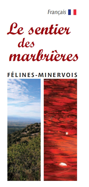
Path of the marble

To download plan pdf
Download circuit pdf in your language
Path of the marble
The path of the marble on the initiative of our assciation.
Circuit buckles some on a geographical scale of Minervois, of a distance of 52 km with uneven of 1991 Mr.
This circuit crosses the communes of Caunes Minervois, Cat-like, Trausse Minervois and Villeneuve and crosses with loops of already existing walks such as:
the road of the sheep with Caunes, the circuit of the dolmen to Cat-like.
the loop can be integrated since the carparks of each of the 4 communes, all crossed by the circuit. Many trade existing are announced by pictograms on the map. Possibility of accommodation in each village and locality.
Each village has mini-buckles communal which caused a card integrated into the report guides Country of Carcassonne.
the beaconing is specific of pink and the accesses to the loop are announced by signs taking again a variation of the M of the Marble logo in Minervois.
a standard panel of information (esplanade) is placed in each commune and of the panels 50 X 50 are put has proximity of each the careers or zone of exploitation.
This project was devolppé by our association, in collaboration with Culture and Félinois Heritage in Cat-like Minervois (34210)
et with the town halls of:
Caunes Minervois
Félines Minervois
Trausse Minervois
Villeneuve Minervois
and service Mme Calmon du CG11
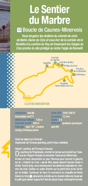
 Buckle of Trausse Minervois
User: Hiker, family Différence altitude: 170 m Uneven positive: 200 m
Beaconing: logo M, color fuschia, yellow arrowing
Carte IGN: 2445 WESTERN length: 10 km
Duration : 3:30 Difficulty: average
Of the carpark of the cooperative wine cave, to take the avenue Marcellin Albert, with the fountain on the right, then straight. On the left, to arrive on the Place of the Trencavel Tower.
Départ Places Trencavel Tower.
Of place de la Tour Trencavel, to take the small street towards north, to pass Old Place and street of the Pump. With the crossroads, to take on the right. Then with the following crossroads to take this time on the left. With the Fork junction to take on the left (northern direction). Then again on the left with the following Fork junction (northern direction). With the crossroads in T, to take on the right, then again on the right. To cross the brook of Canet and to remain on the right. To pass to height of a house located on the line (old sheep-fold of paulignan. Give pleasure with a cup of tea or of coffee, as well as cakes and pastry makings, and benefit from environment peaceful and resting garden, with a splendid sight on Corbières and the Pyrenees. Frauke, the owner accommodates you cordially and proposes cakes and pastry makings to you, facts house, with organic ingredients. All the benefit will be transferred with the profit of the revalorization of the Trencavel Tower in Trausse Minervois.
Ouvert Saturday Sunday the 15th h00 - 19 h00
Réservations 12 Person maximums 06 02 30 49 89) .
Continuer straight 400 meters further, with a crossroadsways, to take on the left while going up (northern direction). In this rise, to see at the edge of the way the dolmen ‶alleys of Jappeloup‶. With the crossroads, to remain on the right, in peak while going up (northern direction). At the top (329 meters), to see a geodetic terminal slightly on the left. To leave the large path of the Marble which leaves on the right, and to take the small path which gœs down (western northern direction). To find the D12/E13 while passing close to a vine on the left. To continue then on the asphalt road with left. To set off the dirt track on the left before arriving at the Smallholding of Bold. 50 meters further, to leave the way of opposite and to take the loop on the right, and 50 meters after on the left. After a series of turns, to cross the ford and to take on the left. To find a way coming from right-hand side and to continue straight (southern direction west) To find the large path of the Marble coming from right-hand side and to continue in the direction of the sout. Passage near the field of Fédou. To take a turn on the right (western direction). Passage near the field of Shamans. To continue the way opposite and to leave the way on the line. To arrive at the vault St Roch with sound water supply point. A lime kiln is 100 meters with the top on the line (private). Then, to set off to Trausse on the left. With the crossroads with the cross, to take the way opposite (southern direction), then street St Roch and Old place before arriving Place of the Trencavel Tower.
 Buckle of FÉlines
User: Hiker, family Difference altitude: 280 m to 610 m Uneven cumulated: 545 m
Beaconing: blue
Carte IGN: 2445 WESTERN length: 13.5 km (walk alone)
Duration : 5:30 Difficulty: average with difficult passages
Departure: place of the Town hall, PR which indicates Planette to 1,1km.
Traverser the temporary russeau Merleau or Merleaux by the metallic bridge. The name of the brook comes from the deformation the grinding ones as merdières then into merleaux because on its course several careers of grinding stones are. To continue straight. With the crossroads of the 4 ways, to take on the right towards the Rivers. To follow the asphalt road in the direction of the Rivers. Further, not to take on the left towards Planette (yellow Beaconing) but to continue straight. After an openwork electric pole in which a wheel of bicycle and a shœ are, to take on the right with the oak located on the fork (forest track). To take on the left with the second fork. One arrives then on a track forstière, to take on the right then on the left. With the two cisterns of the 4 ways, to take straight while going up, to follow the way in lace which gœs up. One notices on the left old field terraces of the ruined village of Ventajou (abandoned around 1360-1370 whereas the bottom of the village, where the old church and the refuge are, was occupied until around 1960). One arrives at the house of Bel Soleil (4 ways), to take opposite the small rise. On the left, the way leads to Ventajou, on the right it gœs down again towards Cat-like.
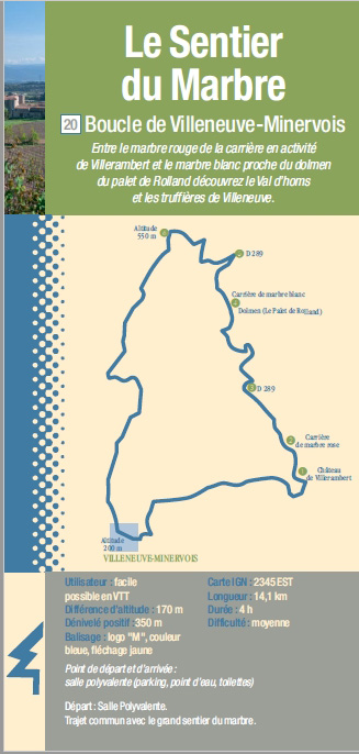
 Buckle of Villeneuve Minervois
User: Hiker, family Difference altitude: 170 m Uneven positive: 350 m
Beaconing: logo M, color blue, yellow arrowing
Carte IGN: 2345 IS length: 14,1km
Duration : 4:00 Difficulty: average
Departure: Versatile room. Common way with the large path of the marble.
Prendre the way which skirts the stage behind the northern versatile room direction. To turn right on D289. With the crossroads with a stone cross, to take on the right. With the crossroads coming from the cooperative wine cave, to continue on the way tarred opposite. To pass in front of a stone cross and to continue to the castle of Villerambert. Separation with the large path of the marble. Vis-a-vis the field, to leave on the left and leave the first way on the right. To take on the right with the junction fork skirting glazing bar on the right. To remain on the way of right-hand side, and to see on the line the marble career of Villerambert. To cross a way and to continue on that of opposite. With the junction T, to take on the left. To arrive on D289 tarred and to turn right to take it. One finds here on the large path of the marble which comes from the Valley of Homs. With height of the carpark on the right, one finds the Career of the white marble and the arrowing of the Dolmen the Palace of Roland. To continue on D289, until finding on the left a dirt track in turn out of pin (alitude 540). With the junction T in peak, to take on the left (altitude 550). To cross a way and to continue opposite southern direction while going down. With the star crossroads, to set off opposite slightly on the left. To go down to Villeneuve by the Capitoul way. To arrive in the village until the place of the Large Fountain and to go down to the crossroads from D111. With the crossroads, to take Which occurred Game of E-mail. On the level of the town hall, to take on the left and arrive in front of the versatile room.
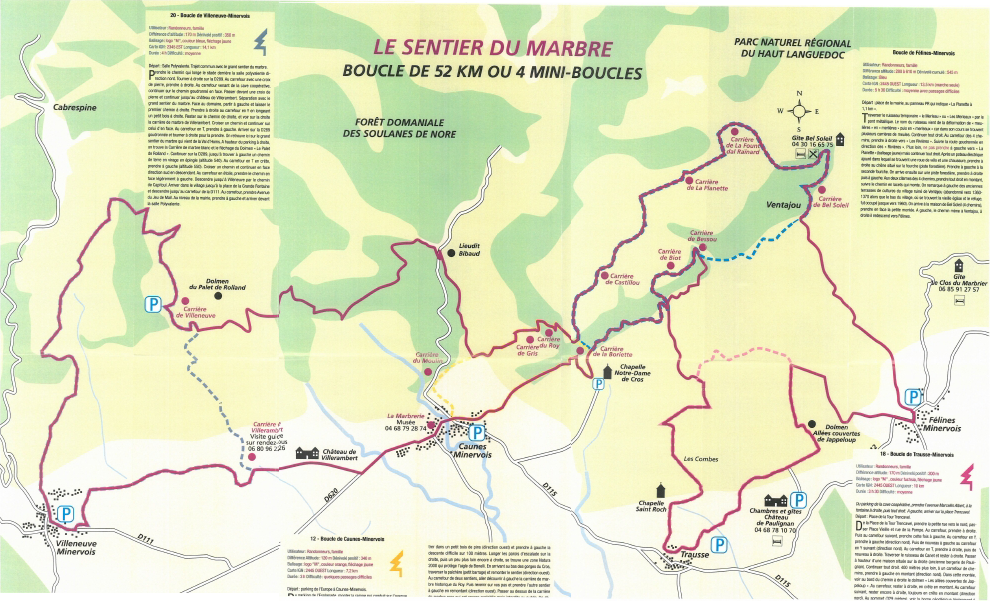
 Buckle of Caunes Minervois
User: Hiker, family Difference altitude: 120 m Uneven positive: 340 m
Beaconing: logo M, orange color, yellow arrowing
Carte IGN: 2445 WESTERN length: 7.2 km
Duration: 3:00 Difficulty: some difficult passages
Departure: carpark of Europe with Caunes Minervois.
Du carpark of the Esplanade, to assemble the slope which leads on the avenue of the Double Money and to go up the Avenue of Minervois. To arrive in top, to descend a little the avenue to turn left on the way of the Cross-country race after being last on the right in front of the old laundrette. All length, you will notice the original stations of the way of cross. To cross another way on the high point (iron cross on the line). To continue opposite. While arriving at the vault of Notre Dame of the Cross-country race, to descend the concreted way on the right, to cross the small ford, to leave the surface of spade on the left screw shaded and to go up by the way of right-hand side (northern direction). With the Fork junction, to go up on the left while following Boriette. 20 meters higher, to go up still on the left. On the line, to leave the dwellings of Boriette. Separation with the large path of the marble which leaves on the right. With the Fork junction, to go up on the way of left (northern direction). While arriving at the pink marble career of Boriette on the right, one finds the large path of the marble. To benefit from the exceptional point of view on the vault of Notre Dame of the Cross-country race, Caunes Minervois, the Minervoise plain and sea, in clear weather. To take then on the left (western direction). To return in glazing bar of pines (western direction) and to take on the left the difficult descent on 100 meters. To skirt the walls of climbing on the line, then a little further still on the right, is a zone Natura 2000 which protects the eagle from Bonelli. While arriving at the bottom of the throats of the Cross-country race, to cross the païchère (small stopping) and to go up the path (western direction). With the crossroads of two paths, outward journey to discover on the left the historical marble career of Roy. Then to reconsider your steps and to take the other path on the left while going up (western direction). To pass to the top of the pink marble career which is still exploited but prohibited with the public. One leads to a broad way suitable for motor vehicles (see capitelle on the left). To set off on the left (southern direction) and to join the Road Napoleon. To pass then in front of a group of art (bridge) on the Road Napoleon and to see an explanatory panel there. With the Fork junction to take on the right and pass the cemented slope. 50 meters further, to continue opposite (western direction) by leaving the way on the right. By leaving the way on the right, to take opposite and pass an open dry stone wall. With the not very visible crossroads, one leaves the large path of the Marble which continues on the line. By overhanging D620, which is the road of Citou, to see the point of view 20 meters after has right. To take the Street of Casserot. While arriving on the Avenue of Minervois, to take on the right, pass on the bridge of the Money Double and to take the staircases on the left which lead to the carpark of the Esplanade of Europe, downwards. Arrival on the Esplanade of Europe.