Types of marbles of the Minervois

TYPE-A3
TYPE-B3
TYPE-C3
TYPE-D2
TYPE-E2
TYPE-F2
TYPE-G2
TYPE-B3
TYPE-C3
TYPE-D2
TYPE-E2
TYPE-F2
TYPE-G2
And here some postcards of 100 years ago
CAREERS
CAUNES-MINERVOIS, village of the marble, knew 32 sitesd' exploitation which were divided into 4 zones:
Garrigues of Villerambert: eight careers were open on this zone of which the great career, the small one of morello cherry, the career close to the mushroom bed careers at Julien.
Une career remained in exploitation under the generic term of career of Villerambert exploited by the company OLD of Khalid Massoud: it is currently the only career in permanent exploitation on Caunes. The characteristic of this site monumental mason is that this exploitation is respectful environment in a spirit of approach to reprocess all waste. This career is opened with the public with visit with accompanying notes on reservation.
La valley of the Double Money: there are no more traces of exploitation of the eight careers of this sector of the road of Citou since years: careers of Cabrerisse, career of Saveloy, rosy marble career, career green of the mouli, concession Eugène Margua, career of saveloy of the Benedictines, concession Thomas Galinier.
Le plate of Terralbes: beside the Career of the King a career is still exploited episodically by an Italian company. The twelve other exploitations are to date in sleep: the career of the hole of the pink, careers of Vitry, the hole of water, the career in the shape of canyon, the career of gray, together of the concessions of Thomas Galinier.
La Bouriette: two careers were listed in the zone with the top of Notre Dame of the Cross-country race: the career of Bouriette, the career Simir Clauzel. The exploitation ended in this part of the territory in the years 2000.
Marble partners careers
MARBLE A.G.E CAREER Marble Red of FranceVillerambert 11160 CAUNES-MINERVOIS
Mobile 06 80 96 22 26 www.marbrerouge.com
Person in charge: Khalid MASSOUD age.marbre-rouge@orange.fr
Kinds of marbles
Marbles of careers in Palace
According to the book MARBLES DE CARRIÈ LMBO IN PALACE text of Pascal Julien.
displacements by terrestrial way were operated only in the event of obligation, when a waterway did not pass near the careers. Such transport indeed did not écessitaient considerable means and a vice of energy which often involved complications with the populations.
In career, handling was done initially by swing by the dash printed with blocks of small and average size, successively reversed on their slices using levers and of grips, of the bars of steel bent out of spatula. This process made it possible to release the scheme of work to gather the blocks near the point of loading. They could be raised with levers or jacks to be installed on logs, in order to be moved by rolling, on especially prepared grounds.
the sledges required a more important handling, to change the stringer, formed by two or three beams in the shape of shœs. The block was raised using levers or of gears jacks, and it was also possible to hoist it with a hoist suspended under a goat, made up by large beams posed in beam. The block was bound by cords to the structure of wood and the unit was slipped on the ground which, according to its nature and its declivity, was reinforced lubricated cross-pieces of wood, posed perpendicularly, as that was still practised until in second half of the XX ème century to Carrara marble. The sledges were also used to leave the parts of the difficult sites, from où one drew them with attelages.
Solidement attached, the sledge advanced on cross-pieces posed on the ground, but it was retained by strong cords that one rolled up several times around these piles, by making them slip only gently. Several men were necessary to this man&œlig; uvre called smoothing, to ensure the ropes and to guide the sledges by the side, using levers. Alternatively, the chief of stringer made detach the cords to change them pile, one of it always remaining in tension. The block went down thus little by little, on several hundred meters.
the last phases of the descent took place by traction of the b&œlig; ufs lorque the slope was not sufficient. B&œlig; ufs which was also used for the charois.
the carriages were to be extremely solid, because an average block reached three to four tons. It was thus necessary to conceive the special ones, with four wheels and raised plate, for the transport of blocks or columns which exceeded sometimes six or seven tons. It was the case for the haulage contractors between Caunes and Narbonne. In minervois, it was with the order that carters ensured the convoys in Languedoc or to the sea, with carriages with two or four bandaged wheels of iron, trailed by mules, horses ferrés.
Les difficulties of crew went hand in hand with those which the ways presented. Those Ci started as of the career, where was made ramps approach to the quay of loading. By 1684, the States of Languedoc had received the order to finance since Caunes a way by where one can make convey the marbles which one draws from this career for Louvre.
In 1748, the way was still impracticable and the bridge was even likely to collapse by the large marble burdens which one was obliged to pass there. The business sucita reports, expert testimonies and recourse, until are found 14,000 books. The Count de Mérinville, whose way served its seignery, will undertake to conclude the restoration of it then the monitoring, and maintenance was given by it under contract to a individual. The repair of the bridge of Redorte, which dœs not serve on the way as the marbles of Roy, was returned to the diocese, charged with the roads communes.
the rafting of the marbles
Once extracted and related to the banks, the marbles were placed on rafts. Those were made by their drivers which cut, conveyed and assembled the barrels. Rare are the indications on the manufacturing of these radeaux.Forts, but however enough short to pass everywhere, they were composed of seven to eight trunks of fir tree at least, strongly bound, an average length of 11 meters, of a diameter from 25 to 60 centimetres, dry of at least a year. Placed on this structure, the blocks were boxed, cased and tightened by wood held by iron ankles, which protected from the clashes with rocks and avoided with the ragiers being wounded. The rafts required out of tumultuous water, an important crew, extremely of an owner and ten to fourteen oarsmen, according to the poids.
Les raftmen hardly appreciated these imposing marble masses which put their life in danger or at the very least their health. Indeed, the descent could not be done, because as of weights enormous which inserted the rafts, that at the time as of high waters, for the short period of the snowmelt, and the ragiers always had the foot in water when they are charged, a water particularly glaciale.
the arrival in Toulouse was done with the Garaud port, upstream of the city. The marbles were again deposited on the ground, with the place known as of Bourdette, for the sale of the barrels of the rafts. In the event of need, the blocks could then be weighed, as Pierre Monge in 1609 using the public weight did it, in order to evaluate the price of the transport.
Les marbles repataient only when they could take seat on new rafts, formed for merchants of Bordeaux. Immediately they were to cross another passelit, that of the reserve of the mills of the castle, which was nothing vis-a-vis the terrible test which expected them a little further, the passelit of Bazacle. There arranged to supply the powerful mills of Toulouse, a reserve placed on a natural roadway caused a jump of more than three meters in height on a fast slope. The glaze of the mill of Bazacle, which makes so perilous the transport of the marbles of Roy, was often described as impracticable cascade où there were many shipwrecks, and où had sometimes to be recovered lost blocks.
Radeliers and marines were numerous with the wire of the Garonne, to ensure an important traffic. However, in period of war, they disappeared suddenly in 1692, Small was without crews to descend the marbles to Bordeaux, because one had enlisted there of force most of the sailors who arrived in convoy to serve the naval army, which gave such a terror. In addition to these difficulties, the gravel pits, the rocks, the islands, or even of the leaning trees could constitute unexpected dangers.
To make as well as possible the waterways navigable had always been a royal concern, and the administration had taken care of it. In 1693, a report regretted of frequent shipwrecks on the Garonne, bus the edges without way, are encumbered trees and trunks, the piles of old dams are not torn off.
the preserved cards of Hippolyte Matis understand those of the course of the Garonne. Large-sized, they consist of twelve parts adding up nearly fourteen meters length, of Pyrénéees in Bordeaux. It are drawn up with the feather on a draft with the pencil, are raised green, red, yellow washings and ochre and comprise, with each title, a comment on the navigability of the portion presented. They are the first complete and precise representation of the Garonne, but also of its accesses. With such statements, the duke of Antin could easily locate the places of which it treated unceasingly, in particular, clearly indicated on the third map of the river, the junction of the royal channel of Languedoc above Toulouse, with the locks which made it possible to make pass on the Garonne the boats charged with the marbles of Minervois.
A two miles of Caunes, the way of the marbles ended close to the village of Puichéric, with the lock of the Needle, où were built a quay of transshipment then a port with warehouse, completed in 1721. By 1684, the rights of car to discharge for the royal marbles were fixed at six sums of money per quintal for each traversed mile.
the sums which had by the royal administration were thus important, because the port of Puichéric was with 23 miles of Toulouse. The states of payment give an idea of the importance of the traffic, in particular for its strongest period, of 1685 to 1689. According to these documents, in four years, they were at least 60,000 cubic feet of marbles of the Minervois which forwarded by the channel, that is to say some 2,200 cubic meters. For this transport, tens of conventions had passed with boatmen toulousins who were to charge with the lock with Puichéric and to discharge with the mouth from the Garonne, où the channel joined the river. The chalans, or coureaux, employees belonged to the marines under contracts or to the company. They were long, narrow and flat-bottomed, the length of eleven canes, width nine steps or approximately (20 meters X 2 meters) furnished with a control surface, mast, tilhac and oars. These boats could carry five to six blocks.
Although surer than in river, navigation was to take into account the periods of dry settings and maintenance of the channel, at the time of low waters of August and September. It yeut there too of the shipwrecks.
Arrived at the Garonne, the boats were charged on the banks with this one, then they were reloaded on broad rafts, extremely of about forty large wooden beams of fir tree. After Toulouse, a calmer course made it possible to place several rafts at the car, with crews on the first and the last only. Another difficulty was born at the time of too strong rains. The Garonne left its bed, flooded the plains and drowned all the reference marks, with the risk to lose a raft far from the banks and to fail themselves in the event of fast fall. Conversely, blocks could be left in edge of river by the raftmen to relieve their rafts during low waters, they remained there then a long time, because to recover them asked considerable means. In the same way, of the too low courses often the departures of Toulouse delayed.
Even remained as the threat of the marbles lost in the bed, like two columns and large blocks fallen to broad from Blagnac as Small vainly tried to recover during years
after weeks of rafting, sometimes tumultuous, sometimes interminable, through poles, of blunders, oars, veils, human and animal towing, the rafts and boats charged with marbles approached Bordeaux, (after more than two hundred and forty kilometers of course from Toulouse). it was then necessary to calculate their progression according to the tides, whose force was felt until Saint-Macaire, in order to arrive at the good moment to attérir in Bordeaux).
the wearing of Bordeaux, which was out of water with each ebb, made delicate handling of products weighty, with important losses. at the XVI ème century and until the years 1670, the marbles arrived at Chartrons, height of the gardens of the convent of the Carthusian one.
the ideal was to coordinate the arrival of the blocks with the presence of a boat ready with transport, but this case of figure was rare. not only there was no question for the raftmen of expecting a ship, but moreover, they did not hesitate to get rid of their loads without worrying to form éceuils for the boats in approach. losses and abandonments many, were accentuated by the long periods of war which often prevented any departure towards Paris and hardly incited with recoveries, at the point to let invade in an anarchistic way this part of the port.
it arrived that the rafts made shipwreck and that the marbles fell into the river.
the entrepreneurs of the Chantemerle company joined a merchant of Rouen, in 1686, to buy to the Holy Agnes , of a port of 300 barrels, at the cost of 9,000 books. they also used in great number of the gribanes from 60 to 100 barrels which were sent to Bordeaux wine, along the coasts. from July 1685 to November 1688, 68 buildings of all tonnages carried of Bordeaux 41,780 cubic feet of marbles of Languedoc. loadings and unloadings were carried out with the expenses of the entrepreneurs.
anxious to rationalize transport, the duke of Antin chose in 1712, for the modification of a royal flute, Bellone , from 200 to 250 barrels, which was especially reinforced for the campaigns which started by 1713. for the loading and handling of the marbles, it had been equipped with ropes, hoists, pulleys and pulley blocks of all kinds as well as four masts for a goat of 50 feet top, of four jacks, grips and crowbars and several ends of masts for rollers. On April 15th, 1714, it was charged with 90 blocks which arrived in Le Havre of Grace on May 4th. on July 5th, it was of return for the second rotation. After leadbeing led until height of Pauillac, in the Gironde, it was joined there by barges from Bordeaux. it charged between 31 blocks with morello cherry with Caunes. what made in all more than 100 m ² and nearly 300 tons of marble on an only one journey. the smallest block weighed approximately 400 kgs, whereas heaviest showed more than 7.5 tons.
A Bordeaux wine, because of tides, it was necessary to place the blocks on rafts or barges which accosted the ships. The store of the marbles was provided with elements of lifting powerful but relatively light, easy to move and use. it was provided out of jacks and levers, pulleys or geared down as in all the elements of a high goat of almost thirteen meters which was used with a portable capstan and a hoist of reserve.
of tens of ropes, thick slings, cables, ropes, hawsers or moorings represented one of the most important expenditures in transport of the marbles. the loading required many carpenters, operations and sailors that it is for Bellone or any other ship when it was not operational any more, after its travel from the Gironde.
labour to make the cargo was employed step by step, which will be extremely expensive, but contracts of handling had also signed with entrepreneurs who undertook the whole of the operations, of the rafts to the boats, to Rouen. the loading was done with slings which one bound the blocks and with goats which one established on the bridge of the ships to raise the marbles with hoists or the capstan of the edge in order to then descend them at bottom from hold. there, they were rolled and arranged on the stays. it was necessary to observe to put the large blocks at bottom of hold and the small tops, waited until we broke fault of having taken this precaution, like had advised it Tarlé in 1712. the blocks were then fastened of wood, blocked between them and on all the sides with beams and corners of fir tree.
the ships left Bordeaux put for some, a few weeks to reach Le Havre of Grace, for others more than three months. according to their draught, those which arrived at broad from Le Havre of Grace were to discharge there or could go up the estuary of the Seine then the river to Rouen. those which could not engage there were lightened of their cargo on flat-bottomed barges.
the loading of the barges, arrived at Rouen, was arranged on the ground, close to the convent of Cordeliers, is transhipped on gribanes, the long ones and narrow flat-bottomed boats. the deposits were provisional, because the departures towards Paris posed few problems, apart from too low waters.
beyond Rouen, the reinforced gribanes of platforms in fir tree went up the course of the Seine slowly, hauled by horses. the convoying of the marbles to Paris was carried out by boatmen of Rouen, who worked with the loading. Paris has the marbles were unloaded a long time with the ports of the conference or the counter. this last was closest to Louvre, with respect to the galleries of the castle, and it was created a store in the vicinity, which comprised a deposit and a workshop of implementation. the court of the castle was then named the court of Marbles. the rough rocks which were deposited there by the carrying ones sharpened for this purpose there were put in work and set out again, worked or outlined to be completed in the sculptors or monumental masons of the king.
downstream, the port of the conference will develop for the reception of the marbles with the building site of Tileries, in second half of the XVI ème century, then remained installed around for their déchargement.
free space made of it the main port used in second half of the XVII ème century. the blocks and columns were placed in a department store, said Bridge-Turning, created at the end of the esplanade of Tileries by Catherine de Médicis.
thus a block extracted from Caunes was initially charged on a carriage, then deposited on a raft starting from the lock of the Needle close to Puichéric. arrived at Montréjeau, it was arranged on the ground then placed on another raft, it was then discharged in Toulouse and put on a new raft to Bordeaux where it again was discharged and arranged in store. When the sea was free, it was placed on a pontoon to be raised on a ship and gotten out thoroughly of hold.
with the harbour of Grace, it was transferred on a barge which carried it to Rouen, where it embarked on a gribane which went up the Seine. arrived at Paris, it was put on the ground, moved and finally deposited in a store.
the HARBOUR
the harbour is a port city of the North-West of France located on Right Bank of the estuary of the Seine in the department of the Seine-maritime and the High-Normandy area. This city became one of the largest French ports by the development of the trade with America. In spite of the crushing argument of the revolutionary period (1789-1815), the port still developed with a transatlantic connection, in particular, thanks to the rise of The United States.
Actuellement it is the second French port after that of Marseilles for the total traffic, and the first French port for the containers.
It is François 1er who founded the port and the city of Le Havre. (Francipolis). In spite of the difficulties related on the marshy ground and the storms, the port of Harbour accommodates its first ships in October 1518. François 1er signed the charter of foundation of the city. The large tower, defends the entry of it. The king moves him even in 1520, makes perpetual the privileges of the Native of Le Havre and gives them its own armorial bearings made up of a salamander. It is under this king that the first building site naval is open in 1524.
In June 1523, Giovani de Verrazano leaves of Le Havre on board the Dauphine one for the Western Indies and discovers the site of New York which it names New Angouleme in tribute to François 1er the silent partner of forwarding.
the modernization of the port begins with the XVII ème century, on order of the cardinal of Richelieu, governor of the city. Le Havre affirms its maritime and international vocation during this same century. At the beginning of the reign of Louis XIV, Colbert decides to renovate the harbour infrastructures: work lasts 14 years. In 1669, the minister inaugurates the channel of Le Havre with Harfleur, called too Vauban channel.
the port of Le Havre occupies northern bank of the estuary of the Seine on Handle. Its situation is favorable for several reasons: it is on one of the most attended seas sphere. Deep water port, it is accessible to all types of ships and whatever their size, 24 hours a day.
CHANNEL OF TANCARVILLE
This channel is a French channel which connects Le Havre to Tancarville and allows a deviation of the estuary of The Seine.
As of the end of the XVII ème century, a channel built by Vauban, connected Harfleur in Le Havre, avoiding with the boats descending from Harfleur the last meanders of the river Basks in the sun and navigation in the estuary of the Seine.
But with the XIX ème century, it is not sufficient any more. The Seine is gradually channeled by means of locked mobile stoppings, and accepts increasingly large boats to Paris and beyond that. The estuary remains a critical zone, and the need is felt a ship canal which would skirt it. New work directly connects Harfleur to the new channel which is commissioned in 1887. The channel Vauban d' Harfleur is then given up, and its influence will serve in the years 1960 with the establishment of the fast track RN15.
the channel, which extends on 25 km from Tancarville in Le Havre, is fed by the Seine with Trancarville and the Crack with Harfleur. Its single lock, to its entry with Tancarville presents a gauge of 180 m on 23 Mr. the damping of the channel is of 3.50 m, and the headroom under the works of 7 Mr.
Among the visible remarkable works since the channel, one cannot overlook the suspended bridge of Tancarville, and the stayed girder bridge of Normandy, which dœs not span however the channel: the first crosses the Seine a few tens of meters upstream of the entry of the channel and the lock, the second crosses the estuary to the south of the alluvial plain whereas the channel runs to north of this one is a few four away kilometers and is crossed by a opening bridge.
ROUEN
Is a commune of the North-West of France crossed by the Seine and chief town of the department of the Maritime Seine and High Normandy.
In the beginning, the city was located on Right Bank of the Seine. Today, it includes the left bank (Saint-Sever District in particular, in the south of the river) and the Lacroix island. The north of the city (Hauts de Rouen), very undulating, is dominated by a plate, où one finds part of the cities of urban area.
La the Seine covers 179 ha of the surface of the city.
the wearing of Rouen was one of the most important French ports of importation of citrus fruits and tropical fruits. The transformation of the port into made the first exporting European cereal port. A terminal for containers has also found place in the port activity.
With the Middle Ages, the prosperity of Rouen rested mainly on the river trade of the Seine. merchants rouanais held since Henri II the monopoly of navigation on the Seine downstream from Paris. An important urban revolt burst and was cruelly repressed by the royal troops. The taxes were increased and the abolished privileges of Rouen for the trade on the Seine.
At the beginning of the XVI ème century, Rouen became the French main port of trade with Brazil, mainly for the dyes of draperies.
the XVI ème centuries was prosperous with the trade of the textile and the activity of the port.
the SEINE
Is a French, long river 777 km, which is thrown in the English Channel between Le Havre and Honfleur.
the Seine is shared in several parts:
the Seine is a very important inland waterway, connecting Paris to the English Channel. So two of the most important river ports of France are there: Paris (port of Gennevilliers) and Rouen which is also an important seaport.
the maritime Seine, as well as part of low The Seine are subjected to the mode of the tides, which gœs up until the stopping of Installations in the Eure (60 cm of marling). One could still observe until in the years 1960 an imposing wave which could reach 4 m at the time of the spring tides and which one calls mascaret, more locally bars. The phenomenon reached its maximum with Caudebac-in-Caux, at semi distance approximately between the harbour and Rouen. It practically disappeared following the alterations made to the river (dredging), damming up and modification of the estuary.
the installation of the Seine in inland waterway, with many stoppings, has creates as many obstacles on the way being opposed migrating fishes.
the Seine is navigable on most of its course.
the Low Seine, with the maritime direction of the term, i.e. of the sea to the bridge Guillaume Le Conquérent in Rouen is accessible to the ocean liners (up to 280 m of length and 150,000 tons). On this part of river, long of approximately 120 km, the three only existing bridges (Bridge of Normandy, Bridge of Tancarville and Pont of Brotonne) offer a head room of 50 m and it river is constantly dredged to allow the boats having a draught of 10 m to circulate. Taking into account the number limited of bridges, several vats allow also to cross the river.
Between Rouen and Paris, the Seine was channeled with the XIX ème century, seven locked stoppings located at Installations-Amfreville Under-the-mounts, Notre-Dame (of Garenne (the Eure), Méricourt, Andrésy, Bougival, Chatou (Yvelynes) and Suresnes (Haut-de-Seine)) allow the navigation of barges railcars (350 T of freight) known as motorized boats of Freycinet gauge, 38.5 meters, motorized barges of rivers (from 800 to 1350 T of freight) of 48 with 70 meters, of convoys of thorough barges (from 3,000 to 10,000 T of freight) and of fluvio-maritime coasters (4,000 T of freight) these barges transport, inter alia things, of the containers, the cars, the oil products, cement etc
HISTORY
From the XVI ème century, the supply fuel wood of Paris was done by rafting on Yonne and the Seine starting from the forests of Morvan.
PARIS
Ranges at the center of the Paris basin, on a loop of the Seine, between two of its confluences. The position of Paris to a crossroads between terrestrial and river commercial routes.
Louis XIV chooses Versailles like residence in 1667, before moving the seat of the government there in 1682; Colbert takes over Parisian management and makes the shuttle between Paris and Versailles. During his reign, the sun king Soleil comes only twenty-four times to Paris, primarily for official ceremonies, thus marking towards the city a hostility that hardly appreciate the Parisians.
The PARISIAN CHANNELS
They constitute a canal system located at Paris and the neighbourhoods, in France, which extends on 130 km from ways from water and understands many technical works such as locks, structures and factories of pumps of water.
This network was carried out by the town of Paris, pursuant to a decree of February 29th floréal year X (May 19th, 1802) of the first consul Napoléon Bonaparte, in order to feed drinking water Paris and to facilitate the transport of the goods and people. Since 1962 the major part of the channel of Ourcq is not used any more for the transport of the goods and the length of the network accessible to the barges is limited to 22 km.
MARBLES WITH the CASTLE OF VERSAILLES
The blocks of marbles are descended to the wearing of Bordeaux by the Garonne on several rafts attached between them. These rafts thus charged are exempted rights of toll. From Bordeaux, they are conveyed by boats towards Le Havre, or if the draught of the ship allows it to Rouen. But the long periods of war which mark the reign of Louis XIV (1672 - 1678), war of Holland (1688 - 1697), war of the league of Augsburg (1701 - 1714) war of succession of Spain will limit the traffic marime on the Atlantic facade.
The blocks go up then the Seine on barges and are unloaded in the wearing of Saint-Germain, Marly, Saint-Cloud, Sevres or Paris (Port of the Conference). Those unloaded in Paris are stored (in Paris, on the island of the city or with the quay of the Small towers) then conveyed by carriage until the deposit of Versailles.
Marble samples
* You can stop the run of the text with your mouse on the text.
* In geology, the term of facies (of Latin which means aspect) It refers to the morphological description of the crystals
*Activate the magnifying glass on the map while passing your mouse above
* Exploited career

* Port monumental mason


Marbles of Mesozoic age (between less 245 and less 65 million years)
1- Roman breach of Baixas (66)
2 - Marble of Saint-Happy (31)
3 - Marble of Montoussé (65)
4 - Marble of Bénou (64)
5 - Marble of Uchentein (09)
6 - Marble of Arudy and Izeste (64)
7 - Marble of Sarrancolin (65)
8 - Breach of the Cape Romain (11), 9- Breach of Aubert (09).
Marbles of paleocene age (between less 65 and less 56 million years)
10- Eastern breach of Baixas (66)
11 - Breach of Verdun (09)
12 - Roman Breach of Saint-happy (31)
13 - Portor of the Pyrenees - Troubat (65)
14 - Breach of Médous (65).
Marbles of the Hercynian chain (between less 360 and less 250 million years)
White marbles:
15 - Céret, Amélie the Baths (66)
16 - Py (66)
17 - Canaveilles (66).
Red marbles Marbles number combinations:
18 - Caunes-Minervois (11)
19 - Saint-Pons-of - Thomières (34)
20 - Saint Nazaire-with-Ladarez (34)
21 - Cat-like-Minervois (34)
22- Villefranche-of-Conent (66).
Marbles morello cherries:
23 - Belloc-Villefranche-of-Convent (66)
24 - Estours (09)
25- Espiougue (09)
26 - Hurdy-gurdy-Louron (65)
27 - Cierp-Gaud and Signac (31)
28- Campan-Espiadet (65)
29 - Hautacam (65). Granite of Sidobre: 30 - (81)
History
HISTORY OF THE MARBLE
The marbles, with the modern direction of the term were formed starting from a gigantic limestone deposit which was carried out between the period of higher Dévonien and that of the Carboniferous inferior, in a time interval of 50 million years between - 380 and 330 million years.In these times there, the neighbourhoods of Caunes were almost covered by the sea, only emerged the mounts of Minervois. In this not very deep sea lived many animals and plants and in particular Goniatites, ancestors of the Ammonites and alive octopus species in a kind of shell, and Othocères, fossil with him also a very right shell.
endans of the million years, with their death, all these animals and plants were found at the sea-bed and accumulated the ones on the others, pulled by the currents and formant of the pockets of accumulation. Mixed with the plankton, these deposits are transformed little by little into limestone dolomic.
It is a phenomenon called metamorphism which under the effect of the temperature and the pressure exerted by the underground plates and with the contribution amongst other things of iron oxide which enables us to have colors and this consitance that one knows with the marble today. The spots and the fossils which one can see appearing were simply forgotten by the process of metamorphism as for example the manganese who appears in the form of the traces grisâtres or black particularly with Villerambert.
The marble of Caunes is extracted from the careers of Caunes-Minervois, small village of the Aude, in the Languedoc-Roussillon area.
Exploited already at the time Roman, it was used much in the medieval construction industries, church and mansions of the area like in Spain, one made use of it to build capitals, columns, retables, like much of decorations.
A little with the abandonment, it is at the beginning of the 17th century that a Genœse sculptor takes again his exploitation, and markets it again successfully.
The career of Roy .
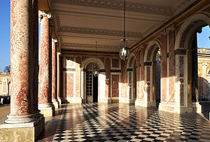
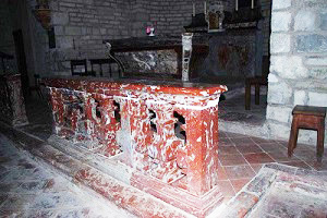
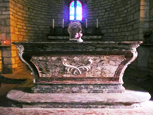
the marble resulting from these careers is the object of a great interest on behalf of the king Louis XIV and his architects, who in fact a material privileged for its palaces in construction. The red marble, incarnates it " of Caunes-Minervois " , becomes one of the most known and prestigious French marbles, because of harmony of its red rosy associated with the softness of its white spots. It is very employed in Versailles, the parts most known are the columns and the pilasters of Large Trianon, one also finds it in the gardens as for part of the columns of the " thicket of the Colonnade "
Les red framings of the pavement of the dome of the Invalids in Paris is also incarnates some of Caunes-Minervois.
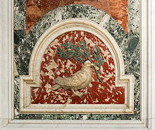
This marble is also one of the only French marbles which was exported as far as Italy, which was the country of the marble at the 17th century, and it became there a very appreciated marble of the architects and baroque decorators. Thus for example, one can find it like basic red for certain panels in the baroque decoration of the pillars of the nave of the St. Peter's Basilica of Rome, those from where are detached from the white marble doves. After the opening of Canal du Midi, a way is built by the States of Languedoc, to join the port of Puichéric, the transport of the stones is thus facilitated to join Paris via the Garonne and the sea. In 1700, an edict of Louis XIV establishes the royal monopoly of material, the career of Malecasse becomes exclusive property of the King. The site is classified today with the inventory of the historic buildings.
Marble with Trausse Minervois
MARBLE TRAUSSE MINERVOIS
The Parish church of the 12th century approximately, has a bedside of Romance style, a nave and Gothic chapels.Inside, one can see a beautiful retable with columns and a Holy marble flame Table of Caunes.
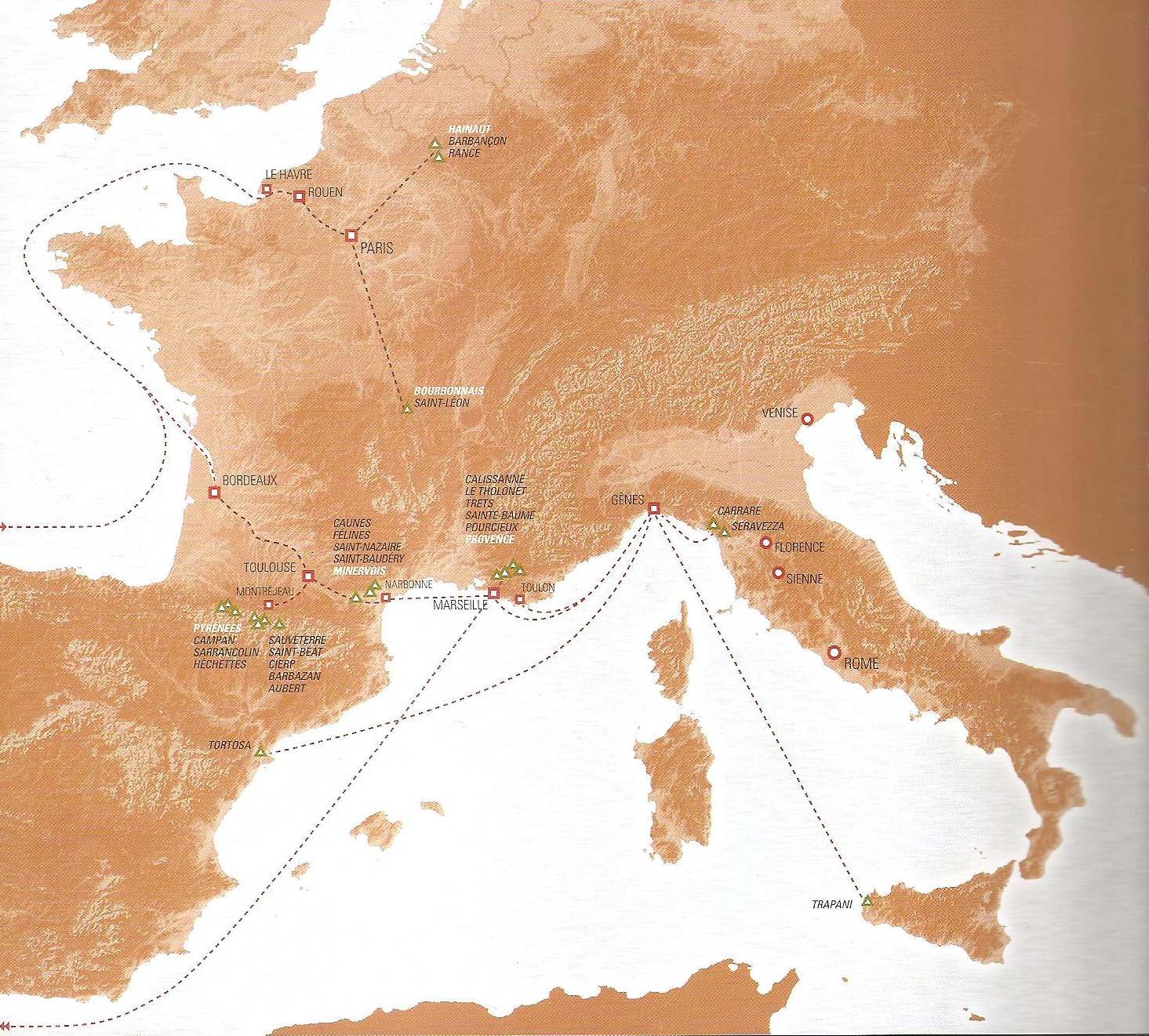
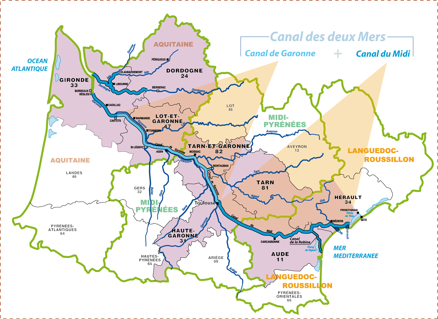
WAY OF THE MARBLE
WAY OF THE MARBLE
Routing, storage and work of the marble.After the opening of Canal du Midi, a way is built by the States of Languedoc, to join the port of Puichéric, the transport of the stones is thus facilitated to join Paris via the Garonne and the sea.
Le extracted marble is conveyed for carriages by the way to the port of Puichéric. The blocks of marble are descended to the wearing of Bordeaux by the Garonne on several rafts attached between them. These rafts thus charged are exempted rights of toll. From Bordeaux, they are conveyed by boat towards Le Havre, or if the draught of the ship allows it, to Rouen. But the long periods of war which mark the reign of Louis XIV (1672-1678, war of Holland, 1688-1697, war of the League of Augsburg, 1701-1714, war of succession of Spain) will limit the sea traffic on the Atlantic facade. The blocks go up then the Seine on barges and are unloaded in the wearing of Saint-Germain, Marly, Saint-Cloud, Sevres or Paris (port of the Conference). Those unloaded in Paris then are stored (on the island of the City or with the quay of Tournelles) then conveyed by carriage until the deposit of Versailles. Contrary to hydraulics or other work in Versailles, the technique of extraction and work of the marble will hardly evolve under Louis XIV, differing little from what it was under the Rebirth. But the size of the blocks and the treated quantity will involve a specialization of the tasks.
WAY OF THE MARBLE
OF CAUNES A VERSAILLES
Le way borrowed by the marbles of Caunes Minevois to join Once Versaillesthe 1666 channel of midday
the police chiefs of the king convinced, work started with installation and the water supply in the black mountain. The construction of the basin of Holy Ironwood, larger artificial water tank of the world, begins in 1167. It will be finished in 1672. The various drains of food are built. Work will take place in 3 phases.
the troçon of Toulouse with Trebes, financed by Paul Riquet even, including the basins and systems of water supply to him will constitute the first slice. Work started at several places at the same time, starting from October 1666. As soon as it was finished, the section was put out of water and its exploitation could begin with a regular connection of the boat of station between Toulouse and Castelnaudary. the second slice financed by the state will begin on June 30th, 1668 between Trèbes and the Pond from Thau. The third slice will consist of the construction of the port of Sète.
the channel will be finished of 14 years, a few months after the death of Paul Riquet (October 1st, 1680). It will be inaugurated on May 24th, 1681 by Daguesseau, intendant of the king. Apartir of May 2nd, an inspection of the state of the dry channel was started. Progressively, the sections were filled. On May 24th, in Béziers, the royal boat crosses with 9 locks of Fonserannes accompanied by an imposing show.
1671
Starting from 1671, the king wanted that one used in great quantity the marble of Caunes Minervois in work of embellishment of the Louvre and the palace of Versailles.
1684
the channel of midday will bring the facility of transport and the improvements in the loading of the blocks. The States of Languedoc préocupèrent transport of the marbles to facilitate the passage of the cars. The new way of the careers ends in the wearing of loading of the channel with Puichéric . On southern bank, one built a lower quay to facilitate the access at the level as of barges, with the lock known as of the Needle. The carts unload the materials which one deposits on barges, sailing on the channel.
Castelnaudary has a port called Large Basin, built between 1666 and 1671. It was used as halt. (For memory the wearing of Carcassonne was built in 1810 when the city was rattachéee with the channel).
Towards the Atlantic, the embarked parts with Puichéric arrive at Toulouse at the port of the Saint Étienne suburb, then taken in hand by the police chiefs.
From Toulouse, from the rafts descends the Garonne, in spite of the reserves of the lumbermen obstructed by the inevitable obstruction. In Bordeaux, civil ships of open sea charge the blocks to Rouen where barges go up the Seine to the port of the Conference, not far from the stores of the king. The period of transport is limited from April to September to benefit from high waters descending of Pyrénéées.
the statement of the Accounts of the king mentions, for the year 1684, of the cords of basin, two masks and vazes for the small park of Versailles. Inside, of the chambrales, the shelves and the hearth of the chimney of the large cabinet of Monsignor.
Le first job of the marble incarnates in Versailles was for the shells which decorate the cave of the park .
But the element the most notable rest barrels of the columns of Large Trianon built in 1687. With this occasion a great quantity of marble of Caunes Minervois made the travel to Paris. Jean Baux provides the many columns and the pilasters necessary to build the peristyle of Large Trianon, incarnates some on the side of the gardens, in morello cherry for the entry.
One will use part of the barrels of the columns of (6.7 and 8 m high) for Versailles, the other blocks was stored in the stores of Chaillot, sites of the royal marbles, and was used in 1808 for the Arc de Triomphe of the Carrousel of Louvre.
Colbert, superintendent of the buildings of the king of 1664 to 1683, created a royal administration of the marble , which supported the purchase of the French marbles clearly. Etienne Ducrot is named police chief of the king for the diecte of the marbles , it often remains in Toulouse and frequently comes in Caunes Minervois.
Around 1674
the construction of the Channel, whose freight of the marble was one of the first uses, allowed a facilitated routing; up to that point the marbles were transported until Narbonne by overland route then embarked on the only possible sea route the passage of the Straits of Gibraltar then the skirting of Spain and Portugal until the port of Le Havre and finally the increase of the Seine. After the construction of the Channel around 1684, the States of Languedoc, concients of the challenges of the transport of the marble, made build a road until the port of Puichéric . The goods, once arrived at Toulouse went up the Garonne and took the same way as before but starting from Bordeaux.
In 1700
an edict of Louis XIV bench the royal monopoly of material, the career of Malecasse becomes the exclusive property of the King, this site is classified today with the inventory of the historic buildings. Thanks to a director and with police chiefs, the superintendent undertakes to control the sale of material and the payment of new the droits.
transport was carried out by inland waterway to the sea, it was necessary to avoid the charois, extremely expensive, from where exploitation in priority of the careers located at the edge of the rivers. The blocks were charged on rafts which descended Neste or the Garonne, rafts which were then exonerated from rights, which constituted a financial counterpart with the difficulties of this transport. These rafts were complex, the blocks were wrapped logs (which constituted a true case) and were thus placed on the raft (this facilitating handling and also protecting the blocks from the shocks which could occur during the rafting). These rafts were guided or drawn since from the towpaths which one maintained regularly. Traction was animal. The blocks were fastened by cords; special nodes made it possible to release them instantaneously in the event of danger. These rafts were sometimes discharged on several occasions. Initially, after being last by Montréjeau, (this port played a regulating role), they were descended to Toulouse and discharged with the Garaud Port (with height of the current bridge Saint Michel) or they continued their courses to Bordeaux. But the passage of the ford of Bazacle was particularly delicate and it had on several occasions to be refitted.
A Bordeaux, with the XVII ème century, the rafts were discharged side city, then in front of the extraordinary increase in the transport and the trade of the marbles of Prénéées and Caunes Minervois, the king bought a ground in 1736 when a warehouse on bank opposed to the Country house was created. In second half of the XVIII ème century, when one undertook the extension of the quays side city, one discovered in the mud of tens of blocks of marble. Each one as with accustomed, was numbered, marked its source and also carried the brand of the entrepreneur who had organized his exploitation., (the brands are flowers of lily, geometrical figures, square, rectangle, triangle, rhombus).
These blocks were in charge in Bordeaux on tradind ships Dutch during the time of peace, then, after conflicts, on warships (Bellone was entirely refitted to be able to transport a maximum of blocks). Discharged in Le Havre or Rouen on boats, they went up the Seine to Paris. Two ports there had been arranged: one was worthy of Tileries, the other worthy of Palace of Chaillot, beside the old manufacture of the Soap factory. From there they were distributed in the royal building sites.
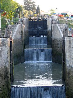
LOCKS
Départ
Lock of the Mills of Trèbes is located at the exit of the small town, downstream from the port. It is in Trebes that the first slice of work finished. It was envisaged in the preliminary draft of 1666 that the channel finishes there. The boats would have then gained the Mediterranean by the course of the Aude. It is also the place of the second lying. The lock of Trèbes is a partly founded triple lock in the rock. As in Castelnaudary, one benefitted from made uneven to build a mill. Further one d^entailler the cliff because the channel is very close to the Aude. It skirts the pond of Marseillette before arriving at the lock of the Needle then at the aqueduct of the same name which allows the passage of the needle or laughs of draining who drains water of the pond in the Aude
L' aqueduct of Lorbiel
This very beautiful work with 3 arches by which the channel crosses the valley of the orbiel was built within Vauban in 1688. It is one of the first large bridges channels builds in France. The principle of crossing of Orbiel was in the beginning very different. A roadway had been built to raise water of Orbiel on the level of the channel. The boats passed behind this stopping to other bank.
works of Fresquel. the work is remarkable and present the characteristic to allow the passage coast beside the channel and of the road. The building work of this bridge channel to 3 arches began in 1802 for acherver in 1810. The bed of Fresquel was cut in the rock. Immediately downstream from the aqueduct is the double lock of Fresquel separate of the lock of simple Fresquel by a basin of 250 Mr. as well as possible to manage the crossing of the 3 locks, the lockkeeper is posted in a watchtower which dominates the site and which enables him to make forward the barges avoiding wasting water.
During the construction of the channel, the town of Carcassonne was left away from the water way. The natural passage consisted in following the valley of Fresquel de Castelnaudary to its confluence with the Aude to the downstream of Carcassonne. Indeed, the valley was separated from the city by rock slopes which required excavations of 20 meters profonderur. The difficulty was not insurmountable but involved significant expenses. By 1669, Riquet had entered in talks with the judge-magus of Carcassonne to make pass the channel under the walls of the city. But he asked for the community a participation of 100,000 books. An influential party prevented the result of the business and the channel passed to two kilometers to North, along the valéee of Fresquel.
On quickly realized made mistake. The charoi of the goods made lose all the benefit of the channel. Little before the revolution, its diversion was decided. The work started in 1787 was completed in 1818. The new section starts to épanchoir it of Foucauld. One crosses then the trench of Estagnol and one passes under the bridge of léna. After the bridge of Peace, the channel widens in a large basin, the wearing of Carcassonne, finished downstream by the lock and the bridge the Marengo one One joined then the old layout in bottom of the Aqueduct of Fresquel. It will be noted that there remains no vestige of the old layout.
Une beautiful lock, but also a stage for the boat of the post office. The halt of midday, to the second day from Toulouse to Agde Dined.
One lock but also a small port or one charged the right-of-way.
East of large basin of Castelnaudary, a splendid staircase of water.
Castelnaudary
Two important dates: commission of the channel of midday on May 15th, 1681 and construction of the ïle of Cybèle in 1754.
Le Large Bassin
On the request of the townsmen, Pierre-Paul Riquet, originator of Canal du Midi and François Andréossy, expert geometrician, made of Castelnaudary the c&œlig; technological of this work, by the contruction of the Large Basin. It is the only stretch of water of this dimension (7ha) between Toulouse and Sète. The point of view on the city is admirable: on a side locks of Roch Saint are L (illustration of the art and the technology of the work; other, the island of Cybèle conceived, in this country of wind, like mole. Imagine this Large covered Basin of barges charging the grain for Sète and the Mediterranean.
At the highest point of Canal du Midi, west of summit pond and on the site of Naurouze.
the threshold of Narouze, sometimes also called threshold of Lauragais, is a geographical threshold (or collar) of 189 m altitude of the south-west of France located at the border of the department of the Haute-Garonne and department of the Aude on the watershed enters the Atlantic Ocean and the sea Méditéranée. It constitutes the highest point of the channel of the South. It separates the Massif Central (in north) from the Pyrenees (in the south). It is close to Avigonet-Lauragrais and to Labastide-in Anjou.
It is located between the village of Gardouch and Villefranche-of-Lauragrais.
Il has there a vault and a bridge channel. It was also the first stop of midday from Toulouse to Agde.
La to only bear a name of animal.
Some modifications since the realization of the Toulouse subway. Formerly there was a mill, and on the bridge of Tiny, of the columns.
The lock called the Garonne dœs not exist any more since the realization of the by-pass of Toulouse.
The communication with the Garonne always exists, but became underground. the first stone had been posed in November 1667.
TOULOUSE the pink city
The installation of the banks modified until its course. Various bridges, ports and locks mark out its layout in its skirting of the pink city before to join the Garonne. One arrives initially at the port Saint-Saver before the channel passes under the bridge of Montraudan. Further, was Port-Saint Etienne who owes his name with the very close Saint-Etienne cathedral. It is there that the Tomb of Pierre-Paul-Riquet near the archives of the channel is. This port was filled lately for the establishment of the ways. Downstream, the Riquet Bridge crosses the channel, come then the lock from Bayard then the locks the Tiny ones and of the Inhabitant of Béarn. The channel finishes its race in the basin of the mouth.
arrived at Toulouse, the boats therefore had not finished their tour of it. They had then to join the ocean. The basin of the mouth in which the channel of midday is thrown is a kind of hopper. It is about a vast lake in the shape of trapezoid in which one reaches by crossing them twin bridges. It is the only Toulouse work to have preserved its original state (put except for the modification of the XVIII ème century). This work formed by three bridges coupled this name carries because it was composed at the beginning only of two arches. The channel of midday arrives by the central arch. When one copes with low marble relief one finds on the right the channel of Brienne which leads to the lock of the Garonne then to the river. The bridge of left was added during construction side channel.)
splendid low the relief out of Carrara marble carved by Toulosain Lucas in 1775 represents l4occitanie, placed at the center which orders with the channel to run the Mediterranean in the Ocean. On the left of Occitanie, the Garonne raises its crowned head of reeds while the Geniuses of Arts dig the bed of the artificial river which must carry them wealths of the two worlds.
the BAZACLE
From time immemorial, the men seems to have crossed the Garonne by Bazacle, left accessible ford on foot. The weak one height of water reviewed of it major passage of the Garonne. In 1190, with authorization of the account Raymond V of Toulouse, a stopping called also fitted of Bazacle was built.
Of new mills was established there, the financing of this complex as well as the expenses of entertien and of operation were ensured by an association of lords. The benefit étaients distributed between shareholders according to the number of shares in their possession.
Bazacle becomes thus the oldest joint stock company with the monde.
CHANNEL DE BRIENNE
Located at Toulouse, in the region Midi-Pyrenees, it runs on 1,560 meters. It is born with the level from the Garonne to the upstream from Bazacle by the lock Saint-Pierre, and joined and the port of the Mouth, not of meeting with the channel of the South and the side channel in the Garonne marked by the Bridge-Twins.
La construction of the channel of Brienne was decided by the States of Languedoc in 1760: the channel of the South passed beyond the walls of the city and joined The Garonne downstream from the roadway of Bazacle. The creation of the channel thus made the downtown accessible by water way. Work began in 1765 and led to the digging of the channel and one port to the mouth of the two channels (with the Bridge-Twins) 1; it was inaugurated on April 14th 1776. With the departure named channel Saint-Pierre, it will take the name of channel of Brienne, in honour of Étienne-Charles de Loménie de Brienne (1727-1794), archbishop of Toulouse.
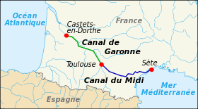
OF TOULOUSE A BORDEAUX
When Pierre-Paul-Riquet completed the channel of midday between Sète and Toulouse, it had the idea to continue it channel in the direction of the Atlantic. However Louis XIV having emptied the cases of the kingdom, the project was quickly given up, for lack of means.
Pendant still nearly two centuries, to convey the goods of Toulouse to Bordeaux, one will be satisfied with the GARONNE river, in spite of so perilous navigation, because to traverse the distance from Toulouse to Bordeaux in going return it takes on average twenty days.
Et as because of the risings of the river, the drought, the GARONNE river not being navigable, the link between the Atlantic Ocean and the méditéranée sea were made along the Spanish coasts, via the strait of Gibraltar. This tour, length of more than three thousand kilometers obliged the browsers to face the barbaresque storms and attacks.
Malgré all these difficulties, the river transport in the south-west of France will remain under operating conditions until the beginning of the 19th century.
the GARONNE
the river receives Nesle with Montréjau, changes direction to move towards the North-East in a broad valley (flat of River ) , it sprinkles Saint-Gaudens crosses the Small Pyrenees between Saint-Martory and Martens-Tolosane, receives Salat descended from Saint-Bosoms.
La length of its waterway, in France east then of 521.9 km.
La very broad valley is staged in terraces on left bank. The river crosses Low wall, receives Ariège with Portet on the Garonne to reach Toulouse where it changes direction into moving to the North-West to throw itself in the Atlantic with its joint mouth with the Dordogne where; the two rivers form the estuary of the Gironde.
Between Toulouse and Bordeaux the Agen river and receives its principal affluents on Right Bank, Tarn and the Batch resulting from the system hydrolic of the Massif Central.
the river is navigable ocean with Langon. A side channel was built with the XIX ème century to join Langon (Castets-in-Dorthe) in Toulouse (connection of the channel of the South). The tide is felt until Casseuil, that is to say 12 km upstream of Langon. characteristic oscillations are also observable in Réole, 5 km plus upstream (when the flow is sufficiently low).
A Bordeaux wine the river is very broad and under the influence of the tides. With rising tide a mascaret is formed which gœs up the river. The salt water of the ocean gœs back to Bordeaux in period of low water level, when the mascaret can be observed until enamont of Cadillac in period of spring tides.
NAVIGATION
Autrefois important axis of navigation and goods transport, the Garonne is not navigable today for more large boats (cargo liners, carries containers) that in its estuary, to the Stone bridge in Bordeaux, and for the large barges until Langon, the continuation being done through the Garonne which is dedicated almost exclusively to tourism fluvial.
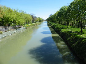
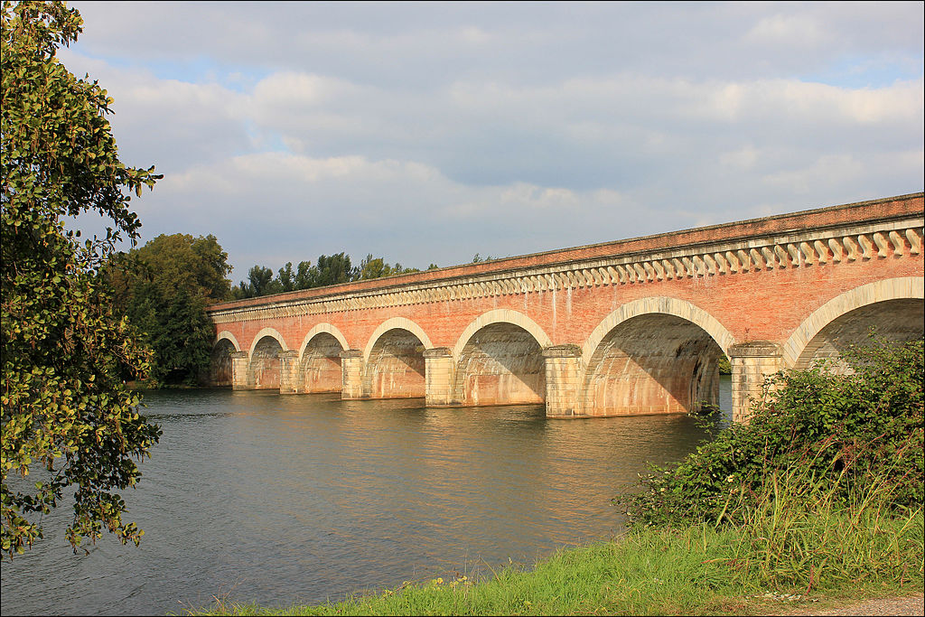
the CHANNEL OF the GARONNE
Se locates in the south-west of France. It skirts alternatively Right Bank then the left bank of the Garonne, that it crosses in Agen by a bridge channel. Length of 193 km, the channel of the Garonne is connected upstream to the channel of the South in Toulouse, and emerges in the Garonne with Castets- in-Dorthe (the Gironde), to 54 km in the south-east of Bordeaux, not where; the river is navigable thanks to the effect of tide. The channel of the Garonne has also connections with:
Le channel is fed out of water by two hydrants in the Garonne.
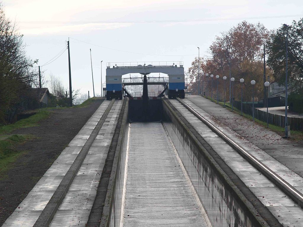
Exceptées the five locks of Montech doubled by the eponymous water slope (1974) all the locks have a 40.5 m length for a width of 6 Mr. Les locks of Montech kept the old gauge of 30 Mr.
De many bridges cross the channel. 83 suspended bridges strew the channel. They all were contruits to adapt in 1933 to modern circulation.
Although its unveiling gœs back to 1856, the channel of the Garonne was in the spirits since antiquity in order to ensure the connection between Mediterranean and the Atlantic Ocean.
Before the channel known as DES TWO SEAS is built, the connection between the two seas required to surf along the Spanish coasts, in passing by the Straits of Gibraltar. This tour, length of more than 3,000 km, obliged the browsers to face the barbaresque storms and attacks.
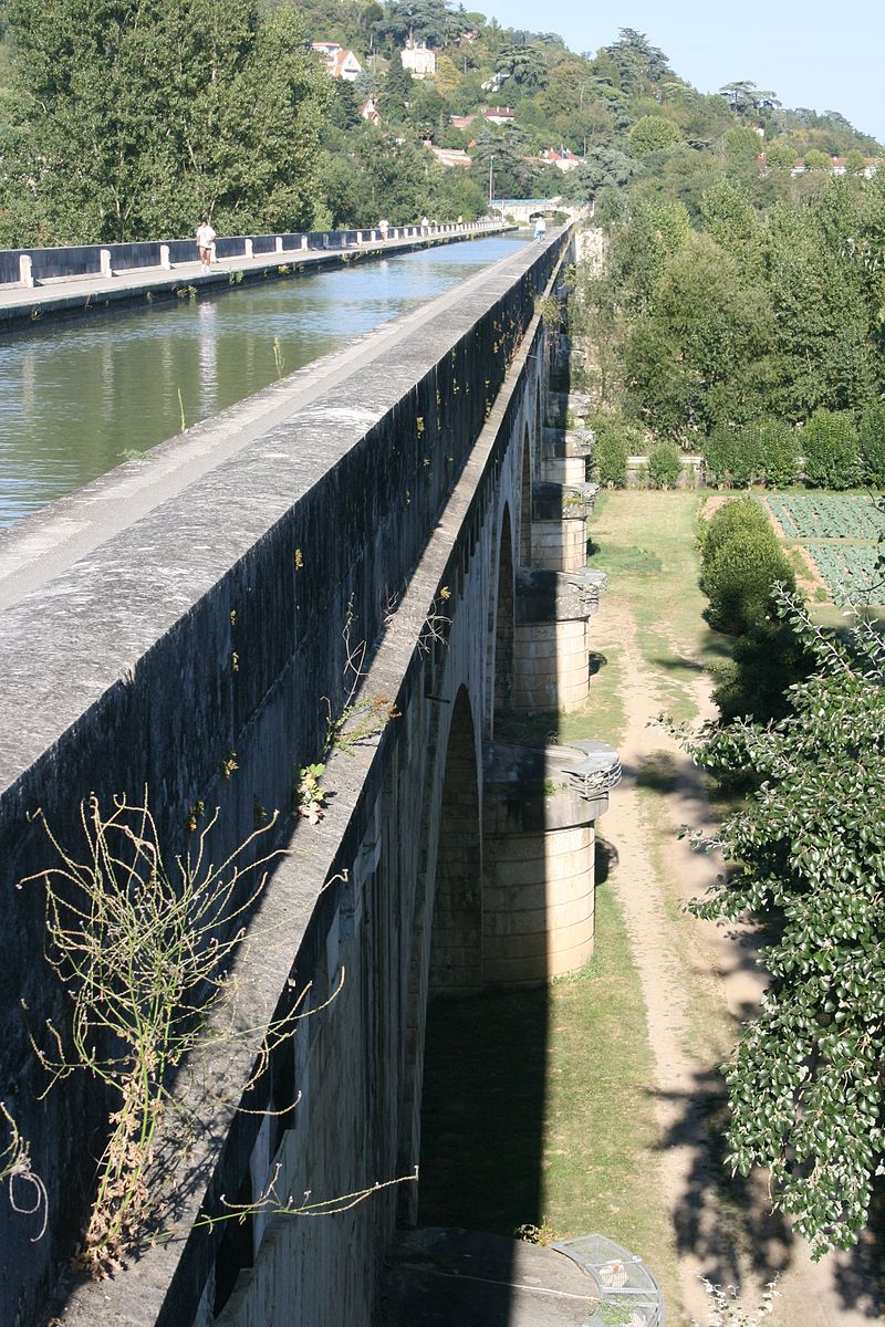
It is only in 1828 that an ordinance prescribes the work study to be undertaken. The study is completed in 1830. France is in its revolution industrial and it is vital for its development to create axes of communication for the circulation of the raw materials. Construction begins in 1838 with a budget of 4 franc million. Work how in several points simultaneously and from the thousands of blue-collar workers will build the few 193 km of way river, carrying out remarkable works like the famous bridge channel of Agen.
In 1844, the section Toulouse-Montech-Montauban (channel of Montech) is open. The channel is opened with navigation upstream Buzet-on-Drops in June 1853 and completed in May 1856.